The week ahead will be critical for the risk of severe weather in southern Brazil, warns MetSul Meteorologia. Several large-scale weather systems will operate in the region for days in a row, generating conditions conducive to severe phenomena with a high potential impact on the population in a state that can be described as particularly dangerous. The effects are still being felt in the Midwest and Southeast of Brazil.
There are three worrying situations in this period of instability between Monday and Thursday: locally strong to violent thunderstorms, excessive rains followed by floods and an extratropical cyclone which can be large and intense with very strong winds.
This is a very different scenario than seen late last week when a low pressure center was forecast to cross the state with heavy rain – and it fell as much as 130mm at some places – without causing strong wind, because, in fact, there was none. This time, the concern is not just about the rain, but also about the potential for intense winds and storms.
This week’s scenario is also not equivalent to that of the June cyclone. It may have significant impacts on infrastructure and the population, but the synoptic conditions differ greatly.
In June, a depression that migrated south from the southeastern coast of Brazil advanced from the sea to the mainland towards the edge of the northern coast of Rio Grande do Sul, where it remained for many hours. From now on, the low pressure will progress from northern Argentina towards Rio Grande do Sul and Santa Catarina, with significant deepening again on the mainland, where cyclogenesis should begin before the cyclone intensifies much over the ocean on the side.
The next few days require huge attention from the public to stay informed of the latest forecast updates by the meteorology as well as directives from authorities in risk areas. We emphasize that this is not a common or ordinary bad weather situation, but a very high risk and weather hazard.
Then, in detail, MetSul will analyze this week’s chart with forecasts and alerts for the main phenomena involved. As this is a Sunday report and the period of instability will last until Thursday, we expect that over the next few days there will be adjustments to the forecast that may affect the rain and wind forecast.
thunderstorm risk
Southern Brazil will experience conditions conducive to the development of isolated thunderstorms for four consecutive days with the possibility of locally heavy rain, lightning, hail and isolated gusts of strong winds. The window of opportunity for isolated severe weather events is between this Monday and Thursday.
Initially, areas of instability are advancing from Paraná to Santa Catarina and the northern half of Rio Grande do Sul on Monday in the form of a warm front. The same regions remain under the influence of the system which becomes semi-stationary over Santa Catarina, the North-West and the North of Rio Grande do Sul on Tuesday, intensifying.
In the fourth, with the deepening of an area of low pressure over the south of the country, the instability will be more generalized over Rio Grande do Sul and will also reach western Paraná and the west and center-west of Santa Catarina. On Thursday, a cold front associated with a cyclone is advancing through Santa Catarina, Paraná and Mato Grosso do Sul to the east with rain and isolated thunderstorms.
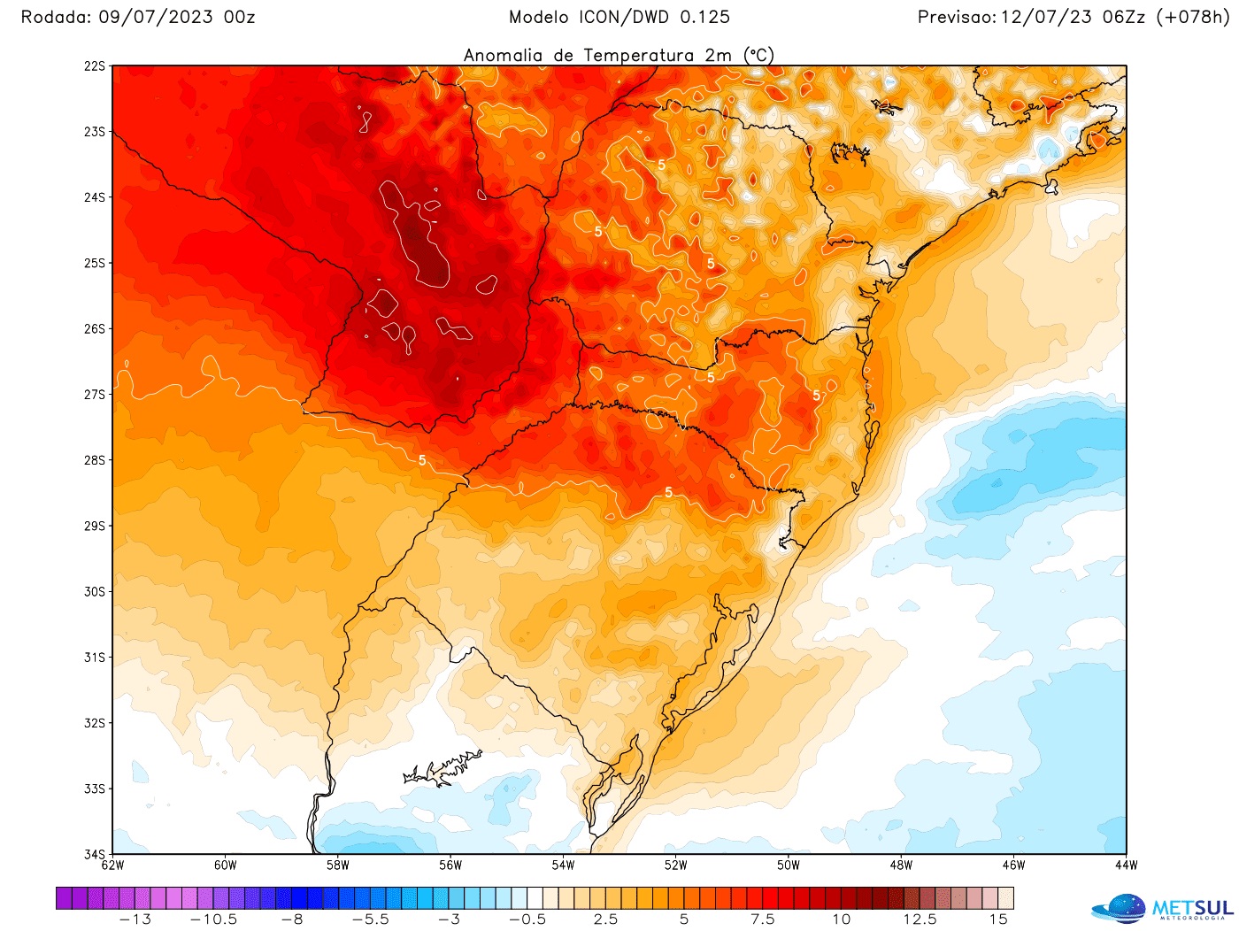
The frontal system between northern Rio Grande do Sul and Santa Catarina, before the cyclone forms, will split colder air to the south and warmer air to the north, a condition that will not only favor heavy rains, but also isolated storms.
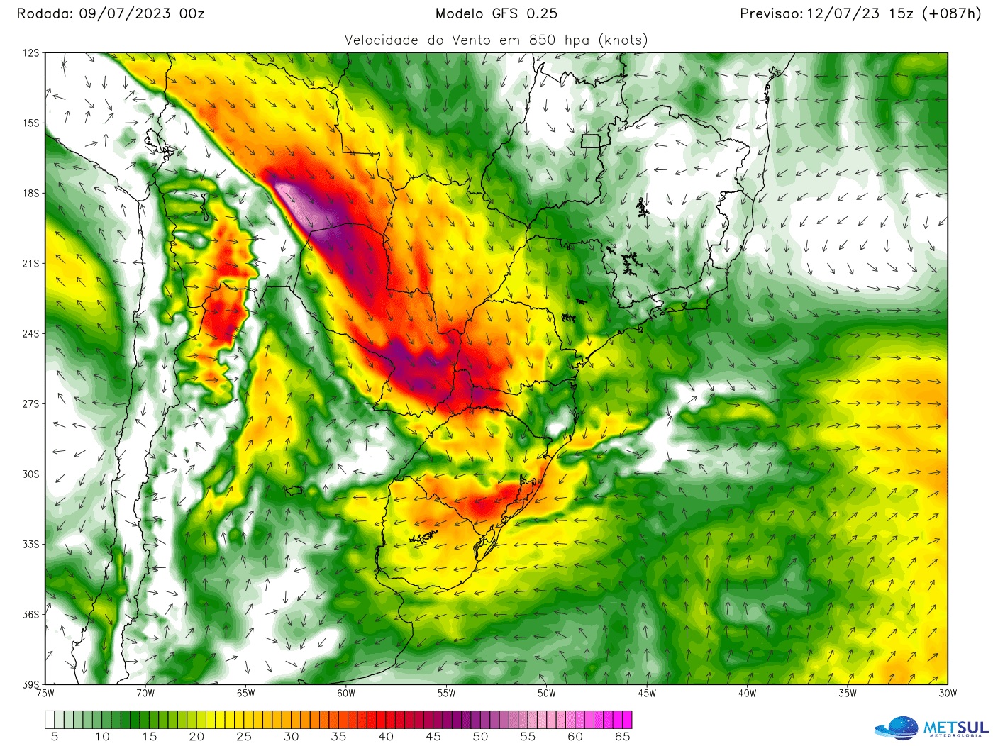
As if that were not enough, there will also be a strong jet stream (wind) in the lower layers of the atmosphere, originating in Bolivia, carrying warm tropical air towards southern Brazil and intensifying the instability, this which increases the risk of storms.
With the sharp drop in atmospheric pressure, the contrast between warm air and colder air or even the action of the low-level jet stream, locally strong thunderstorms with the risk of isolated episodes of violent winds cannot be ruled out. The risk is higher in the northern half of Rio Grande do Sul and in the west and west-central Santa Catarina.
Excessive rains and flooding
MetSul Meteorologia also warns of the likelihood of heavy to excessive rain in part of southern Brazil this week. Cumulative figures for this week alone are expected to be between 100mm and 200mm in many cities with the possibility of marks exceeding 200mm or 250mm in some places.
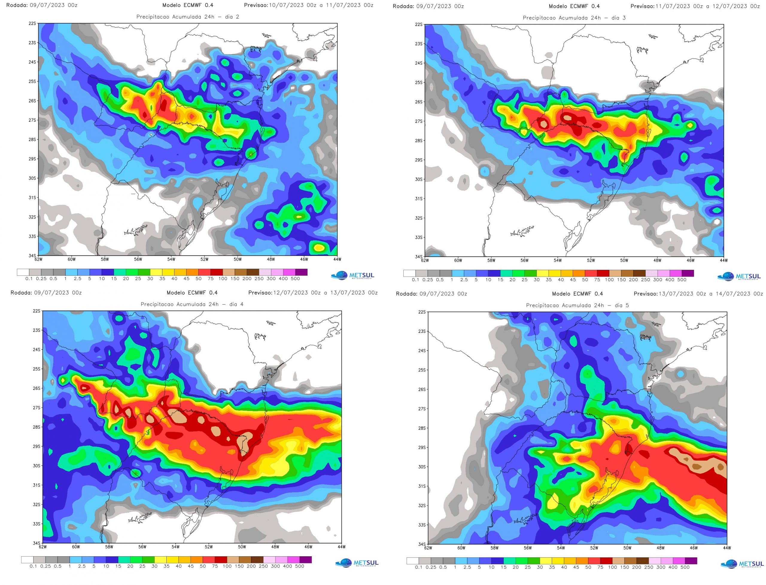
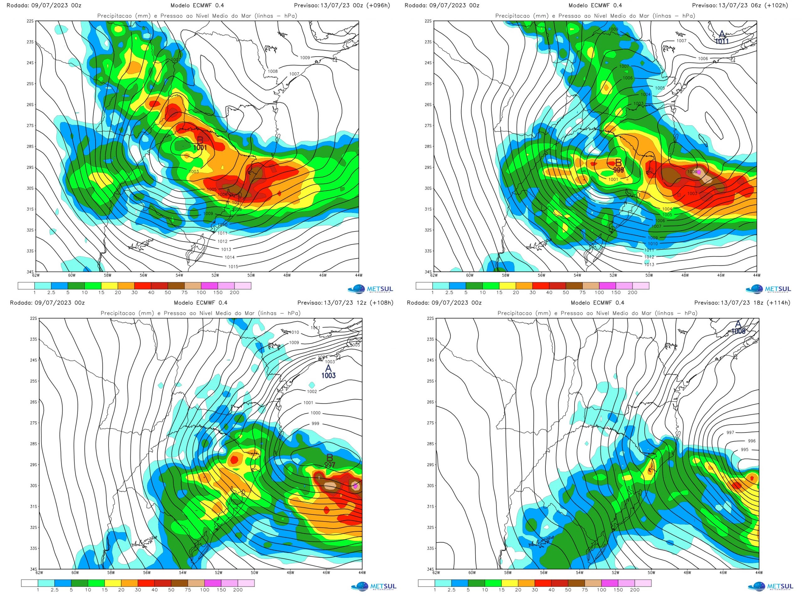
The maps below illustrate the predicted rainfall scenario for the period of greatest instability. These are the day-to-day rain projections of the European weather model in which between this Monday and Tuesday we observe the tendency to rain more in Santa Catarina, the northwest and the north of Rio Grande do Sul. Between Wednesday and Thursday, with a cyclogenesis (formation of a cyclone) on the continent, in southern Brazil, the rain intensifies a lot.
On Friday, due to the circulation of humidity from the cyclone already over the sea, it can still rain at various points, especially further east in southern Brazil, with isolated heavy showers, but a gradual reduction instability will begin.
The most critical period of rain in Porto Alegre and the metropolitan area will be between Wednesday and Thursday. During these two added days, rainfall in Greater Porto Alegre could exceed 100 mm, according to today’s data. With a cyclone forming over Rio Grande do Sul, downpours are likely to be torrential at times and capable of generating high volumes in a short interval, increasing the risk of flooding.
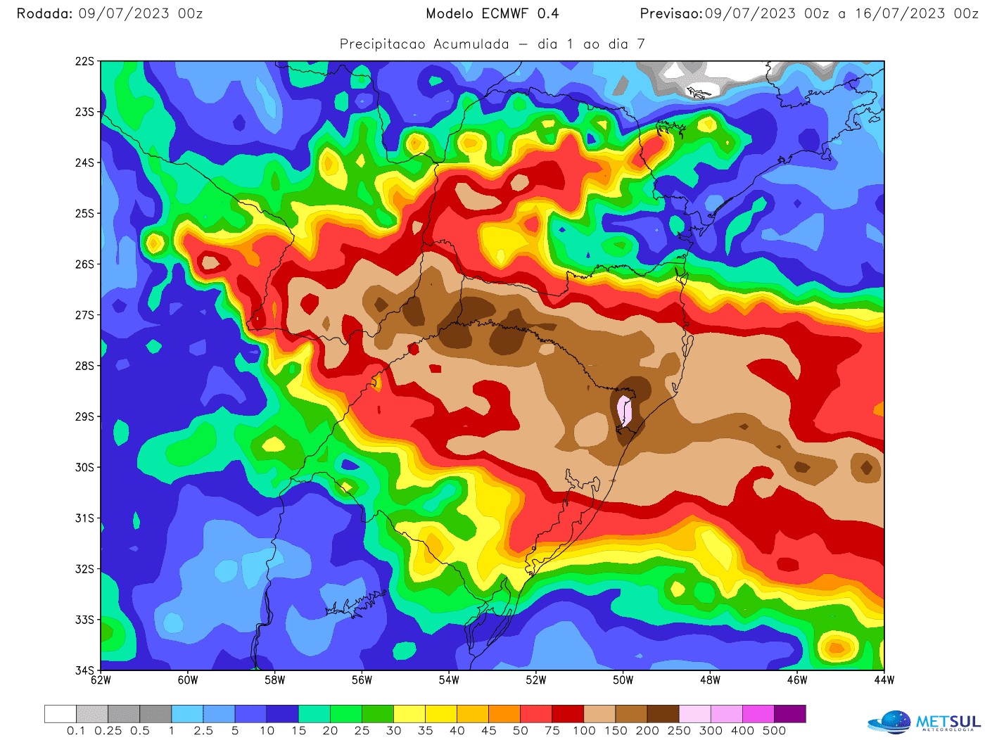
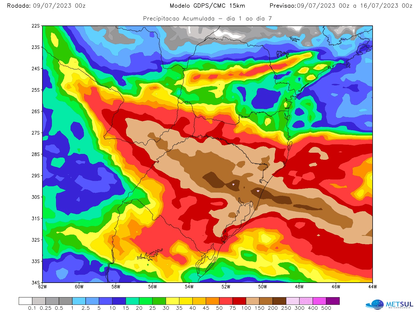
The rain scenario becomes even clearer if we look at this week’s precipitation totals, which are projected by the models and clearly show why precipitation can be excessive and cause problems. The maps below show the seven-day rainfall projections for the German Icon models, the European model (ECMWF) and the Canadian model.
All models indicate rainfall this week of 100mm to 200mm in a wide area between the northern half of Rio Grande do Sul and part of Santa Catarina with accumulated at some points 200mm to 300mm. Points in other regions, however, can experience heavy rain, particularly between Wednesday and Thursday with wider instability due to the formation of the cyclone.
These volumes are sufficient to generate floods, flash floods, landslides and the collapse of roadblocks. However, there is an aggravating factor. This rain will fall on areas that just received heavy rain between Friday (8) and yesterday (9), when it rained 70mm in Greater Porto Alegre and parts of the North West, and up to 100mm to 130 mm on the north coast, in the valleys and part of the Alto Jacuí.
That is to say, some cities may have the sum of the two rainfall events, the one just recorded and the one arriving, accumulated from 200 mm to 400 mm in a single week. With the rivers already heaved by what has rained and what is yet to rain, river flooding will be inevitable and there will be flooding.
The most excessive rain volumes in Rio Grande do Sul will be concentrated exactly in the regions that had the highest volumes at the end of last week and, worse, where the greatest number of rivers in the territory of the state of Rio Grande do Sul are located, in this case the northern half. Thus, from now on, it is necessary to be aware of the risk of flooding in rivers such as the Jacuí, the Sinos, the Caí, the Taquari and the Uruguay, among others.
Hurricane
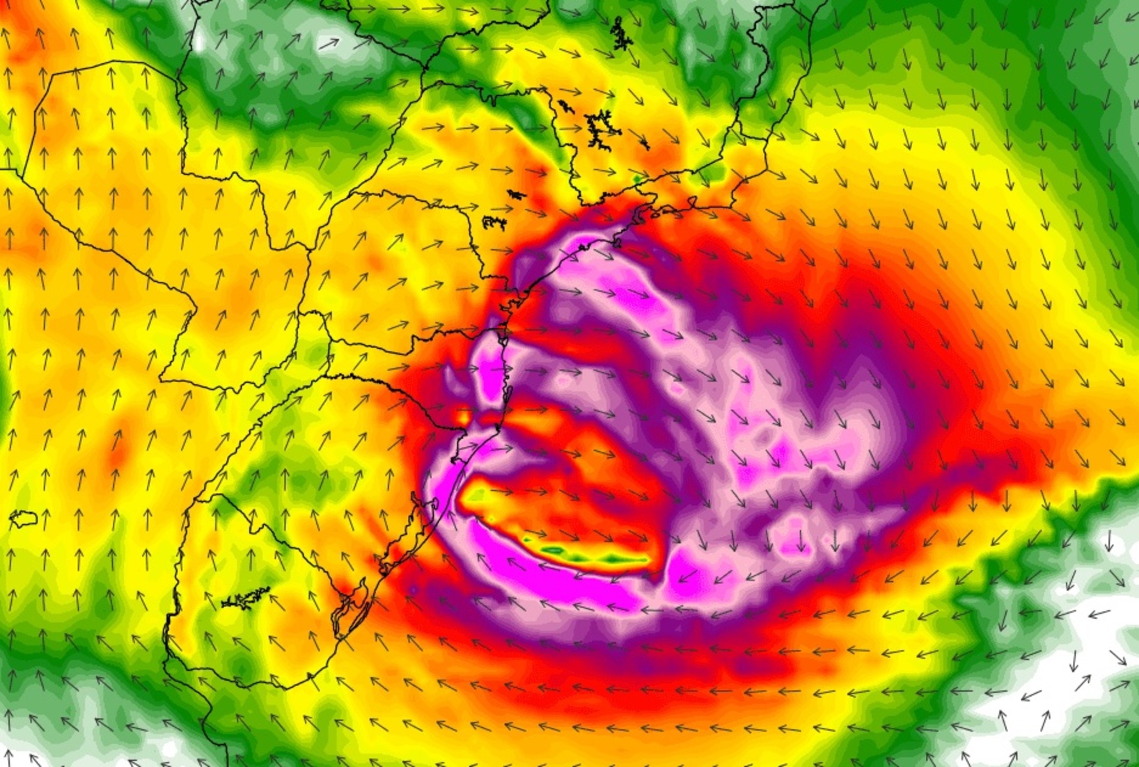
An extratropical cyclone will act in the second half of this week, reinforcing the rain and bringing strong to intense winds with the likelihood of disruptions and damage, such as falling trees, roofs and lack of light. It is a more intense cyclone with greater extension and range.
Unlike all the cyclones that have affected southern Brazil in recent months, cyclogenesis (formation of cyclones) should take place on Wednesday on the mainland and not at sea. Heading towards the ocean, on the south coast of the country, the cyclone is expected to intensify between Thursday and Friday.
Normally, in cyclones, the strong to intense wind is concentrated in the south and east of Rio Grande do Sul as well as in the areas of the southern plateau and the coast, in Santa Catarina. The scenario described for this system, however, is different. As the cyclogenesis will take place over land, on the continent, the number of places affected by strong winds tends to be much greater.
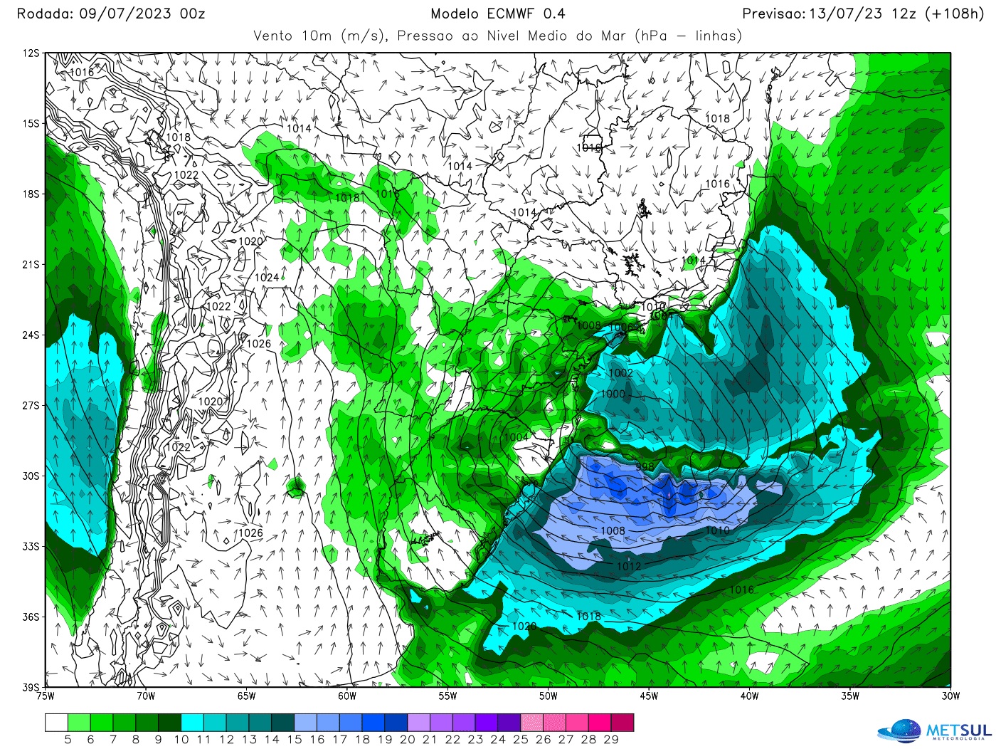
Thus, winds of 60 km/h to 80 km/h can be recorded in most cities of Rio Grande do Sul with gusts exceeding 100 km/h in some places, according to today’s data. The strong wind field of this system must be so wide that the strong wind can still reach many cities in Santa Catarina and Paraná, as well as in Mato Grosso do Sul, São Paulo, Rio de Janeiro and possibly even in the southern Minas Gerais.
The strong wind field should be very wide over the ocean with very strong wind on the sea, it is already possible to anticipate a high probability of intense maritime agitation with surf and storm tide, strong in sectors from the coast, on the coasts of the south and the south-east of Brazil in the second half of this week.
We point out that the model projections for this system have fluctuated a lot and it takes three to four days until it forms, so it is certain that there will be changes in the wind intensity projections and areas. most affected.
Therefore, it is crucial to be aware of the updates that will be released by MetSul, especially on Tuesday and Wednesday closer to the episode, which tend to be more accurate. Likewise, it is recommended to avoid posts on social networks by those who are not meteorologists and who have been developing scenarios without technical rigor for days and who are unaware that this is a fluid situation subject to change.
How to check for map updates
All maps in this newsletter can be viewed at any time by our subscriber (subscribe here) in our maps section. The platform offers maps of rain, frost, temperature, hail risk, wind, humidity, air pressure, snow, soil moisture, and fire and lightning risk, among others variable, with updates two to four times a day, depending on each simulation. In the maps section, it is also possible to consult our very high resolution WRF model of MetSul.

“Prone to fits of apathy. Beer evangelist. Incurable coffeeaholic. Internet expert.”

