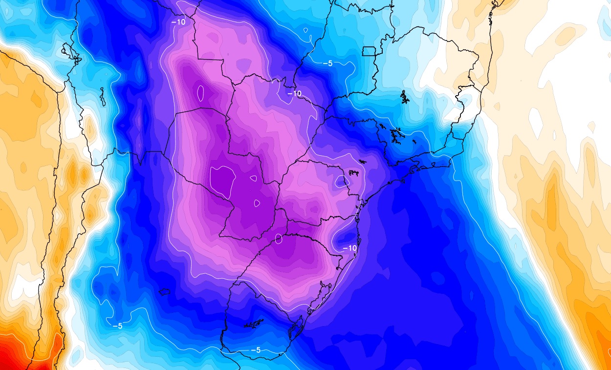
A powerful cold front followed by an unusual and no less powerful cold air mass will advance towards southern Brazil at the start of the week with rain, thunderstorms which in some cities can be violent with intense winds, and a fall which MetSouth meteorologists describe as “brutal” with temperatures typical of July through mid-October and early November.
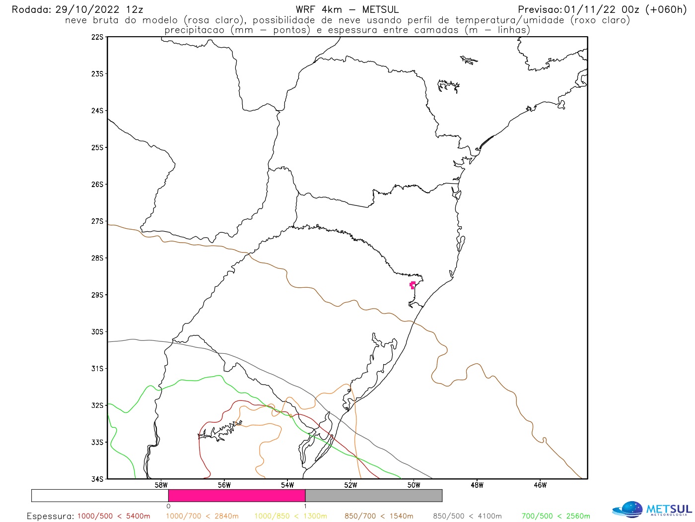
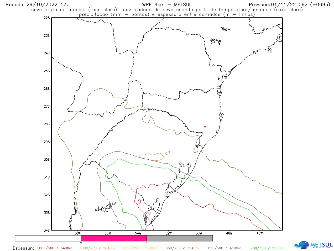
The polar air mass is so intense and outside of normal patterns that some day patterns have suggested the possibility of snowfall earlier in the month in the higher elevation areas of southern Brazil, which has never been recorded in November for a century. observations. “It’s the kind of forecast we never imagined we would do, the possibility of snow in November,” says meteorologist Luiz Fernando Nachtigall, from MetSul, with 40 years of weather forecasting experience.
“It is a sui generis situation, very different from normal, because we are facing an incursion of cold air which, in mid-November, will be intense in the center-south of Brazil and will reach Peru. and the Amazon region, which is only seen in winter polar air masses, with the reminder that we are much closer to summer right now,” he comments.
Meteorologist Christian Caravaglia of the Argentine National Meteorological Service shares this perception. The Buenos Aires weather professional described the weather-changing cold front between Argentina, Uruguay and Rio Grande do Sul this Sunday as “enormous” and called the incursion of cold air that will follow a ‘”extraordinary”.
A powerful cold front will bring storms
THE MetSul Meteorologia warns that a large wave of thunderstorms will precede the entry of cold air this beginning of the week. Locally severe thunderstorms are expected by MetSul for central and northern Argentina, Uruguay, south-central Brazil, as well as Bolivia and even Peru.
“The risk of severe storms with gales and hail of varying sizes, in addition to locally heavy to intense rain, is very high,” warns Nachtigall. In Rio Grande do Sul, the front advances from the afternoon to Sunday evening and until the early hours of Monday. The frontal system will then reach all of Paraguay, the other southern states, the Midwest and part of the Southeast on Monday.
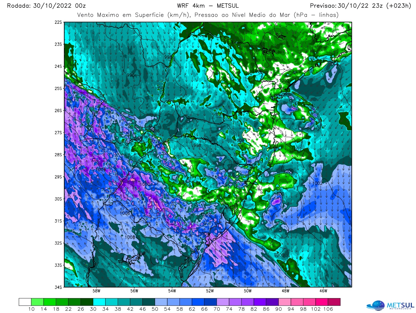
According to MetSul’s warning, the cold front is so powerful that the frontal system may reach parts of northern and even northeastern Brazil, such as the interior of Bahia, with rain and thunderstorms on Tuesday. “One of the main concerns we have in the advance of this cold front will be the onset of windstorms which in some places can have gusts with destructive force. There will be a combination of factors to exacerbate the risk of locally intense and violent windstorms,” says Nachtigall.
“First, the cold front is going to move very quickly and fast moving frontal systems tend to bring strong winds. Second, the atmospheric pressure will be very low, increasing the risk of storms. And, finally, the front will preceded by very warm air and will be followed by very cold air, a condition that also favors windstorms,” warned the meteorologist.
In addition to gales, isolated superstorm cells are expected to bring hail of various sizes, which in some places can be medium to large in diameter. Even the risk of tornadoes cannot be ruled out as the cold front moved through Brazil’s south-central states earlier this week, MetSul warned.
Cold air mass of unusual intensity for November
An extraordinary mass of cold air penetrates this beginning of the week in Rio Grande do Sul. The cold, associated with a mass of polar air with a continental trajectory which will progress through the interior of South America, will lower the temperature in the South and in part of the Center-West, the South-East and even the North of Brazil.
“It will be a remarkable event from a climatological point of view. Although it is not uncommon to be cold in November, the intensity of this mass of cold air will be very different from what is common for the penultimate month of the year,” reflects meteorologist MetSul Estael Sias. “It will be very cold, which would be very normal for winter, but it is absolutely unusual for November with temperatures 10°C to 15°C lower than the historical averages for the month,” he said.
The coldest dawn of the week must be Wednesday, even if it is cold before. Porto Alegre can have between 8ºC and 9ºC while Aparados and Planalto Sul Catarinense can register -3ºC to -5ºC. Much of the interior of the gaucho should have minimum temperatures around or below 5°C. The border with Uruguay, for example, can register 1°C to 3°C on Tuesday and Wednesday, with persistent cold with less intensity on Thursday and Friday mornings. In higher elevation areas of southern Brazil there is a risk of negative marks on the fourth, fifth and sixth, but on Tuesday peaks such as Morro da Igreja may already have marks around 0C or negative.
The cold air mass begins to enter from the west and south of Rio Grande do Sul at the end of this Sunday and will invade the state during Monday. The thermometer marks drop sharply on Monday and remain low on Tuesday. In the second half of the week it will begin to warm more in the afternoon, but still with temperatures well below normal for November and with cold nights.
Historic and unprecedented snow chance
Computer numerical models have indicated a chance of freezing rain and/or snow every day since last weekend. The most recent data, from yesterday to today, has greatly reduced the chances of the phenomenon and indicates a small possibility between the 1st and 2nd in Planalto Sul Catarinense and Aparados da Serra, in Rio Grande do Sul.
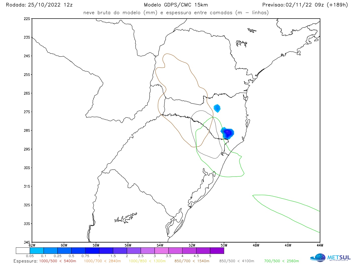
The Canadian model for 10/25 came to indicate snow further north of Santa Catarina and with accumulation, but in later rounds it did not indicate such a scenario | METSUL
Over the past week, while the models indicated snow every day, the Canadian weather forecast model – which best predicted snow on the first day of spring – sometimes even suggested snow with accumulations and the record high. phenomenon even last week. North of Santa Catarina and south of Paraná, however, in the most recent departures, he did not indicate such a scenario. A pattern that continues to indicate a chance of snow is the WRF, but with very isolated occurrences.
“It is likely that it snowed in November in the 18th and 19th centuries, at the end of a climatic era known as the Little Ice Age, but over the past 100 years there are no records or historical document that shows snow in Brazil in November,” he explains. Estaël.
According to geographer Nilson Wolff, author of the book “A Neve no Brasil”, the last documented record of snow in Brazil occurred at the end of October, unprecedented for the November phenomenon. The episode took place, according to historical records, between October 19 and 20, 1946 in São Francisco de Paula.
Cold air will enter with a strong wind
Cooler air enters late today and early Monday in Rio Grande do Sul with strong to sometimes intense gusts of wind from west to south, accompanying a very sharp drop in temperature. Wind is common when more intense cold air masses enter at any time of the year and even more so during incursions that occur during warmer periods, as is currently the case.
Strong to intense winds are also expected with the arrival of cold air in the regions of Mato Grosso and Mato Grosso do Sul, especially in the more western cities of the two states, where the cooling will be accentuated, as well than on the southeast coast. Region. The very strong wind on the high seas due to the cold advection should still leave the sea rough with the risk of surf on the beaches of the South and South-East coasts.
Frost worries about the risk of losses on the pitch
The cold will pose a risk and it is high for agriculture, after all frost is expected and at this time of year when the phenomenon occurs it tends to be confined to higher altitude towns, like Aparados and the southern plateau of Santa Catherine. This time it can freeze very late in low and medium altitude municipalities, which in the case of November is rare and reaches the beginning of the summer harvest. “If late frosts are already worrying the countryside in September, imagine in November,” says Estael.
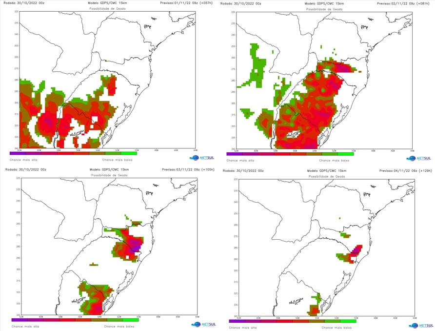
The days most likely to freeze are November 1-5 (see how to follow the frost forecast). The first day, in the more western cities of southern Brazil. Between 2 and 3, the phenomenon tends to generalize and affect a large number of municipalities. On days 4 and 5, the frost would be more concentrated in higher elevation locations.
In 2007, a year analogous to 2022 in MetSul climate analyses, November had a powerful mass of cold air by November standards in Argentina. The production areas were confronted with frost, in many places, between November 11 and 15 of that year. At the time, according to Argentine peasant organizations, the loss of wheat amounted to 1.5 million hectares or 200 million dollars in damage.

“Prone to fits of apathy. Beer evangelist. Incurable coffeeaholic. Internet expert.”

