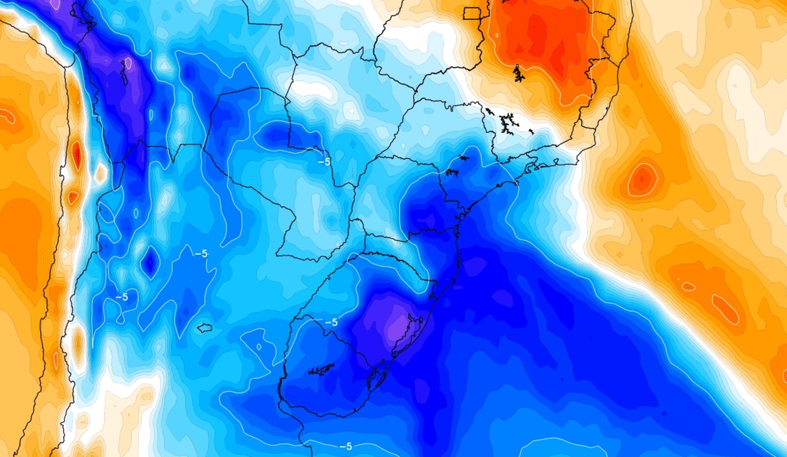
MetSul Meteorologia warns that a strong cold air mass corresponding to October standards is currently progressing through Argentina and will reach Brazil, lowering the temperature in cities in the south, central west and southeast of the country. The influence of cold air will be stronger in the southern region, especially in Rio Grande do Sul.
Much of South-Central Brazil is currently under warm and humid tropical air, but the weather has already started to change with rain and thunderstorms in the state of Rio Grande do Sul due to the moving cold front in front of the cold air. mass of polar origin.
Colder air begins to enter Rio Grande do Sul from the afternoon to evening of this Wednesday, which will bring daytime lows to these areas this evening. During this Thursday, the cold air mass advances, covering the three southern states and reaching areas west of Mato Grosso do Sul and south of the state of São Paulo. On Friday, milder air covers more areas of the Center-West and reaches the entire state of São Paulo, Rio de Janeiro and part of Minas Gerais.
This cold air mass will be associated with a center of high pressure which, in the early hours of Friday, will be over the Rio de la Plata, between Montevideo and Buenos Aires, with a surface atmospheric pressure of 1,027 hPa. Precisely, this high pressure center will guarantee a few consecutive days of sunshine for the Gauchos.
In Argentina, cold air caused the temperature in the early hours of Wednesday to drop to 9.4ºC below zero in the town of Maquinchao, in Rio Negro province. In the tourist town of Bariloche, today’s minimum temperature was minus 4.3ºC at the airport. Previously, cold air caused spring snows further south in Patagonia, Tierra del Fuego.
What to expect from cold air
The influence of cold air will be greater in cities further south in Brazil which will be close to the center of mass associated with the Prata anticyclonic center. The cold therefore tends to be stronger in the municipalities of Campanha, south of Rio Grande do Sul and on the border with Uruguay. Further north, in the Center-West and South-East of Brazil, the influence of the air mass will be much weaker and will represent much more of a reduction in temperature compared to the heat it created rather than cold.
On the border with Uruguay, Campanha and Serra do Sudeste, minimum temperatures can drop to 2ºC or 3ºC at dawn on Thursday, 1ºC to 3ºC at dawn on Friday and around 4ºC or 5ºC at the start of the SATURDAY. In Campos de Cima da Serra, the coldest region of Rio Grande do Sul, and in Planalto Sul Catarinense, clouds will prevent further cooling on Friday, but on the weekend, in clearer weather, it could be 1 °C to 3°C.
Porto Alegre and the metropolitan region will experience their coldest dawn on Saturday due to the clearer weather. It could already be a minimum of 12ºC or 13ºC on Friday, but on Saturday the region is expected to have 10ºC to 12ºC early in most places with minimums below 10ºC in some areas of Greater Porto Alegre.
In the capital of Rio Grande do Sul, although there are no very low minimums, the afternoons tend to be quite mild or pleasant during the cold air. Thursday afternoon, it will be cold with sometimes strong southerly winds which will bring a weak thermal sensation. The temperature should not exceed 16ºC or 17ºC. Friday, maximum around 19ºC. And on Saturday, it’s only 22ºC.
With rain and fog, Thursday afternoon is also expected to be very cold in Serra Gaúcha, Campos de Cima da Serra and Planalto Sul Catarinense with temperatures around or below 10ºC in several municipalities. The cold wind from the southern quadrant, sometimes moderate to strong, will reinforce the feeling of cold.

Curitiba will have cold afternoons on Friday and Saturday, but especially Friday with maximums that should not exceed 12ºC to 14ºC. On Sunday, thermometers will already indicate between 16 and 18°C in the metropolitan region of the capital Paraná.
In the city of São Paulo, the cold air will be felt more in the maximum temperatures than in the minimum temperatures, with much lower temperatures in the afternoon. Highs for Friday and Saturday are expected to be up to 10ºC below normal for October with temperatures of 16ºC to 18ºC. The end of Friday and the beginning of Saturday are expected to be between 12ºC and 14ºC in many areas of the capital of São Paulo. In the city of Rio de Janeiro, much milder and unstable afternoons Friday and Saturday.
A cold air mass will bring frost
Every time a cold air mass of greater intensity enters at this time of year, rural dwellers become very concerned about the risk of late frosts. Fortunately, frost is not expected to affect the main grain-producing regions of southern Brazil, according to MetSul projections. The maps below show the Canadian model’s frost projections for Thursday, Friday and early Saturday.
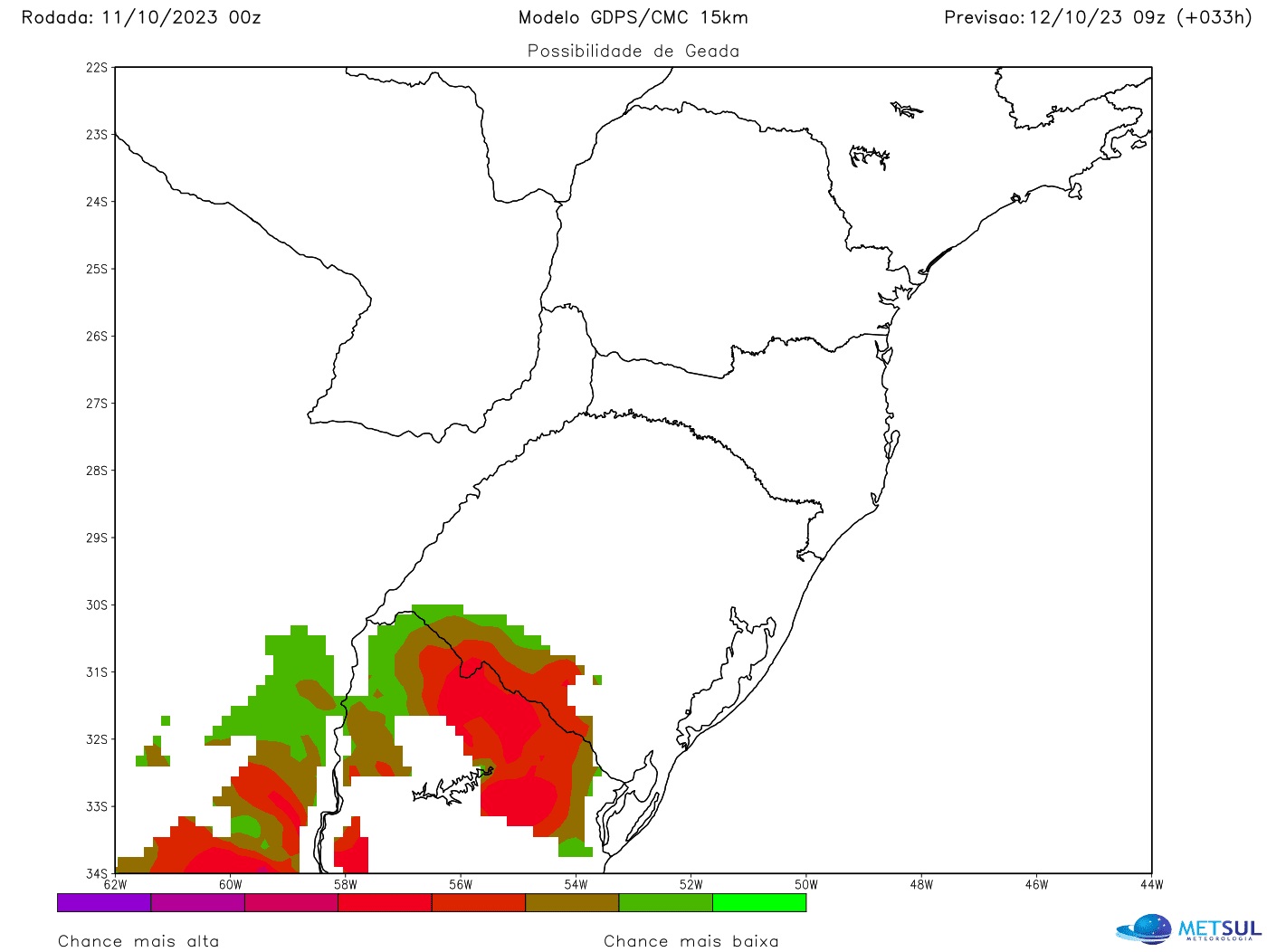
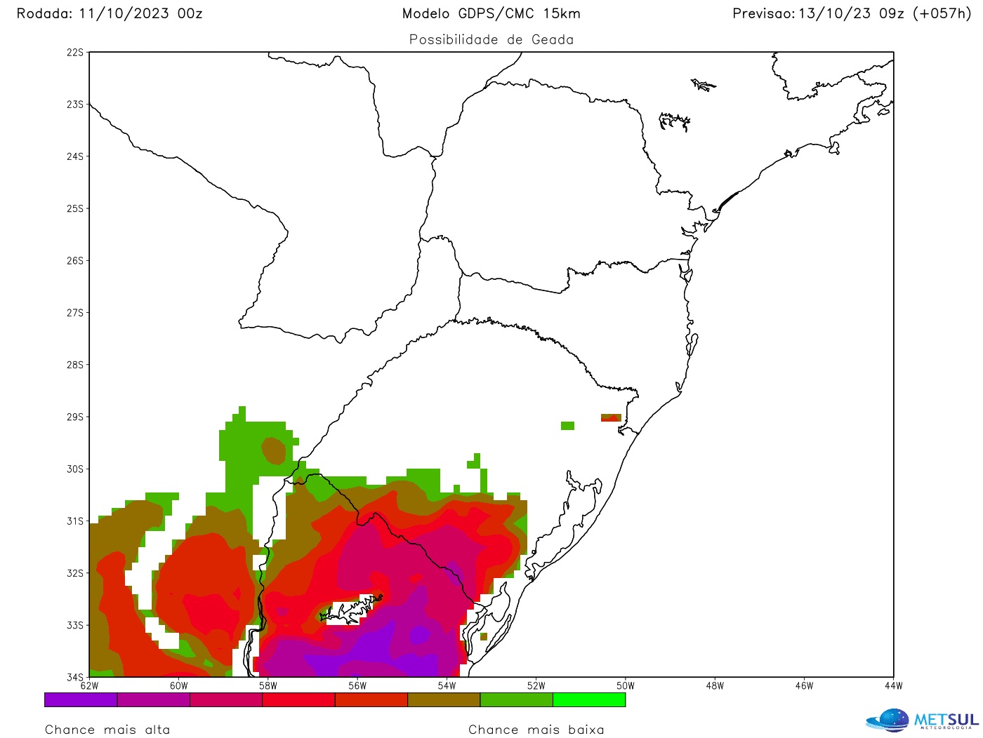

As we can see, the greatest tendency is for frost in Campanha, in the Serra do Sudeste and on the border with Uruguay, especially in the early hours of Friday. On Saturday, the risk of snowfall increases in the São José dos Ausentes region and on the southern plateau of Santa Catarina. In the cereal-growing areas of the Middle Plateau, frosts could be weak and isolated in the lowlands.
How to view maps
All rain maps in this newsletter can be viewed by our subscribers (subscribe here) in our maps section. The platform also offers maps of rain, frost, temperature, hail risk, wind, humidity, atmospheric pressure, snow, soil moisture and fire and lightning risk, among other variables, with updates two to four times per day, depending on each simulation. In the maps section you can also view our very high resolution WRF model from MetSul.

“Prone to fits of apathy. Beer evangelist. Incurable coffeeaholic. Internet expert.”