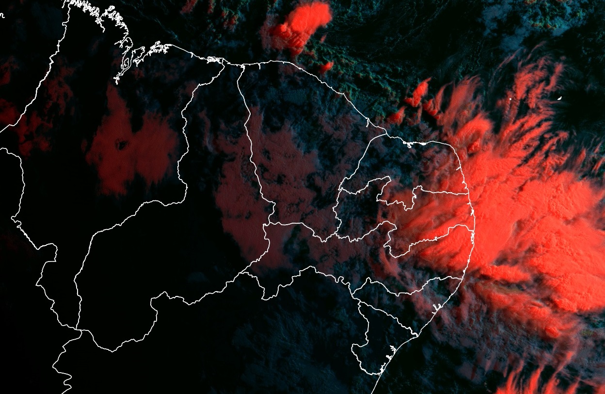
Heavier rains could return to parts of northeastern Brazil in the coming days. Atmospheric models indicate that the rains in the east of the region will have two main causes: a cold front and waves from the east. The frontal system of the second half of this week will act by the sea and will stimulate the formation of clouds laden with blows in particular between Sergipe and Pernambuco. This system which will advance over the ocean and trigger new episodes of moderate to heavy rain, especially between the Zona da Mata and the Litoral and perhaps even part of Agreste.
Subsequently, the second cause of instability will be the typical phenomenon of this time of year called “eastern waves”, which are impulses of instability that spread from the African continent to the Brazilian northeast. Eastern waves tend to arrive in the Northeast for several days in a row with less intense, but frequent, rains expected.
HEAVY RAIN THIS WEEK
Based on the US model outputs below, it is possible that this Wednesday the rain will occur with a higher volume on Sergipe, with a projection of around 40 mm. On the other hand, throughout Thursday, the rain is gaining in intensity and is also hitting Alagoas and Pernambuco. Once again, accumulated highs are expected in the Greater Recife region within a few hours. According to the projection of the American model, it can rain about 100 to 150 mm in 24 hours. Very high volume in a short time which again can bring inconvenience to the area.
Daily rain forecast for northeastern Brazil according to the American model | METSUL
Recalling that Recife experienced a real drama last month due to excessive rains that caused floods and landslides. Friday, the rain continues in Alagoas and Pernambuco, however, it tends to lose intensity.
From June 20, the waves from the East will propagate towards the North-East coast and will tend to maintain the presence of instability. In principle, the models do not indicate such high accumulations of rain, but the last few weeks have seen a lot of rain in the region and a vulnerability to so many days of instability and volumes exceptional precipitation is high. According to data from the center Accumulated national disasters approached 1000 mm.
Daily life: Pernambuco has new landslides and deaths due to rains rise to 129 https://t.co/OQJ0dJDJ2h
— Folha de S. Paulo (@folha) June 7, 2022
Sucupira, in Jaboatão dos Guararapes pic.twitter.com/1ap9fnTsL2
— Renato Barros (@renatorbarros) June 3, 2022
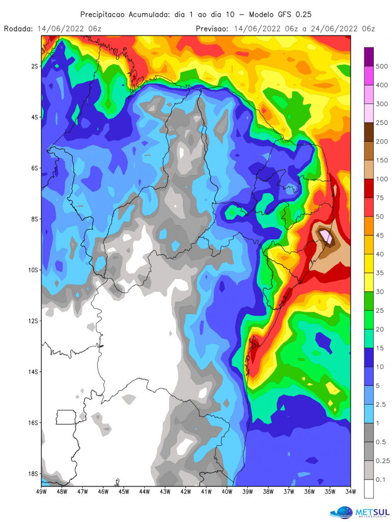
Anyway, analyzing the various rain forecast models for the Northeast in the coming days, there is some consensus regarding the potential for heavy rain events, especially in the eastern part of the region. . The US model below indicates that the heaviest rainfall tends to be more limited to the Coast Range, from Salvador south to the Rio Grande do Norte. In this zone the protrusion is on average 75 to 100 mm. At the same time, the northern coast of Alagoas and Litoral and part of the Zona da Mata de Pernambuco stand out, with accumulations greater than 100/150 mm. At the same time, the model even indicates a rainfall amount around 250 mm in part of eastern Pernambuco.

Projection of heavy and voluminous rains in the Northeast over the next 10 days from the GFS model | METSUL
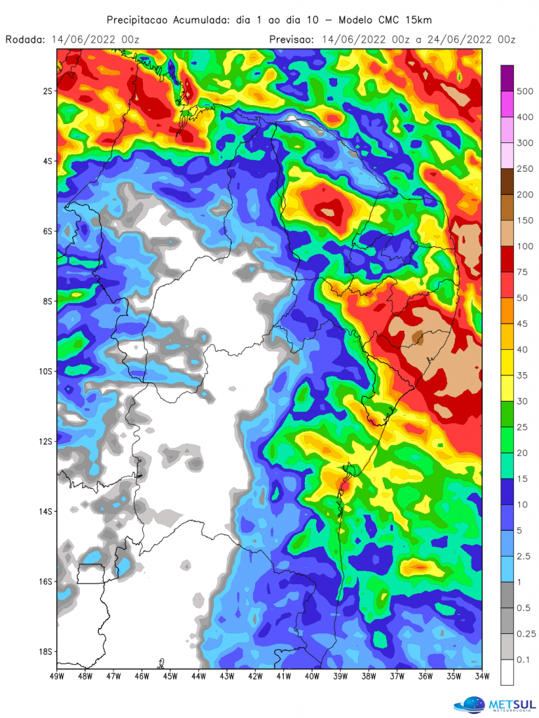
In this sense, the Canadian model solution projects heavy accumulated precipitation over the next 10 days, however, it concentrates the most expressive rain between Alagoas and the eastern half of Pernambuco. In this area, the projection indicates accumulations of the order of 100 to 200 mm which can occur even in the Agreste of Pernambuco. On the coast of Bahia and Alagoas, the model indicates volumes around 30 to 50 mm.

Projection of accumulated rain in the next 10 days by the Canadian model | METSUL
WHY DOES IT RAIN SO MUCH IN THE REGION?
In advance, we have already attributed the primary cause of the short-term rain to the passage of a front and the waves coming from the east. However, before that, there is a global event in action since last year that plays an important role in the region’s rainfall pattern: the La nina weather phenomenon. In addition, this La Nina event is the most intense in autumn since 1950 and one of the consequences is the increase in precipitation in parts of northern and northeastern Brazil. At the same time that the Atlantic Ocean at the height of the northeast has warmer than normal waters and this can contribute to intensifying the instability in a more local way, that is to say the rainy events that reach the Brazilian northeast.
🌎 SPECIAL – WEATHER | La Niña has increased in intensity in autumn since 1950, analysis of the @metsul based on data from @NOAA. The phenomenon affects the climate worldwide and has an impact on rainfall and temperature in Brazil. https://t.co/1UxYQ54K9Y
— MetSul.com (@metsul) June 8, 2022

“Pop culture fan. Coffee expert. Bacon nerd. Infuriatingly humble communicator. Friendly gamer.”


