Merchants; municipal and local elected officials; in addition to marinas and sailing clubs in the towns of Paranaguá, Antonina, Morretes, Guaraqueçaba and the region; received the first units of the Map of Communities of the North Coast of Paraná.
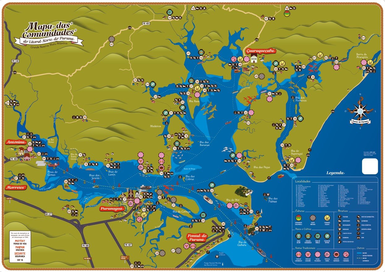
The material, prepared by the public company Portos do Paraná, was delivered in the last week of November and brings together information from 65 communities, including caiçaras, indigenous peoples, quilombolas and artisanal fishermen.
The map supports all people who use the estuarine complex region, which encompasses Paranaguá Bay, Antonina, Guaraqueçaba, Laranjeiras Bay and Pinheiros Bay. “I would say that the coast of Paraná is a big diamond in the rough, which is not known to a large part of the population of Paraná. Here it’s like the garden of Paraná, with a large Atlantic forest reserve, and people don’t know their own garden. They often travel to the Amazon, to the Pantanal, but here there are regions as beautiful or even more beautiful than there,” underlined the Director of Environment, João Paulo Santana.
The map brings together information on waterways, highways, roads and trails, as well as points with restaurants, inns, gas stations and warehouses. Leisure places are also marked, including: sport fishing; hiking trails; and places suitable for surfing, cycling, diving and aerial sports. The map shows where religious, musical and gastronomic festivals take place, such as the traditional Festa da Tainha; and secure anchorage spaces for sailors.
It took the state-owned company more than a year to collect all the information needed to create the map. During the construction process, several meetings were held between town halls, the Paranaguá Port Authority, residents and specific groups such as sailors, fishermen, scouts, cyclists, local traders, among others.
The map also shares summaries with general information and local sights. One of them is the story of Canadian sailor Joshua Slocum, who lived in Guaraqueçaba in 1887 and recorded the first circumnavigation of the world alone 11 years later.
One of the collaborators in the preparation of the map was Donyan Greipel, secretary-director of the Iate Clube Pontal do Sul, who helped by providing anchor points and navigation details, as well as some tips for building the material. “I received the printed map, I thought it was really cool, the map was very educational and although fun, it allows estimated navigation of the points that were placed on the map,” said Donyan .
Another person who received the printed card was the Secretary of Environment and Sustainable Development of Guaraqueçaba, Cassiano Lopes. He specifies that he will deliver the units to the municipal secretariats and the town hall. “The material is very good, it contains comprehensive information about the region. This will be of great value in promoting local attractions and communities in our municipality,” the secretary emphasized.
The next steps of the project will be to distribute it to new meeting points on the coast and in the communities served by the ports of Paraná. “People have really enjoyed receiving the cards, especially in restaurants and hotels, because they will be able to hand them out to visitors. Many also appreciated the information on sailing routes. Our goal is to deliver the specimens to as many communities as possible in the coming months so that everyone has access to this rich material about the culture and services of our coast,” said Jaqueline Dittrich, biologist from Portos do Paraná.
The map is also available on this link.

“Evil pop culture fanatic. Extreme bacon geek. Food junkie. Thinker. Hipster-friendly travel nerd. Coffee buff.”




:strip_icc()/i.s3.glbimg.com/v1/AUTH_da025474c0c44edd99332dddb09cabe8/internal_photos/bs/2024/x/2/N6XJkFRYWxJY6hAeUEtw/betty2.png)
