
A cold air mass is advancing in southern Brazil this Thursday and has already lowered temperatures across Rio Grande do Sul with temperatures below 5ºC in several cities in the west and south of the state in the early hours today with more open weather and the air was dry in these areas while the northern half of Rio Grande do Sul continued with lots of clouds and rain.
Stations of the National Institute of Meteorology recorded earlier today a minimum of 4.1ºC in Jaguarão, in the state of Rio Grande do Sul; 4.2ºC to Pound; 4.6ºC in Bagé; 4.8ºC in Canguçu; 5.3ºC in Caçapava do Sul; 5.4ºC in Dom Pedrito; 5.7ºC in Santiago; 5.8ºC in Quaraí; 7.0ºC in Encruzilhada do Sul; 7.1ºC in São Gabriel; 7.6ºC in Uruguaiana and São Vicente do Sul; and 7.7ºC in Tupanciretã.
Private automatic stations reported dawn and dawn minimums of 2.2ºC on Thursday in Pedras Altas and Pinheiro Machado; 3.3ºC in Herval; 5.0ºC in Lavras do Sul and Jaguari; 5.3ºC in Piratini; 6.0ºC in São Martinho da Serra; 6.4ºC in Julio de Castilhos; 6.6ºC in Cachoeira do Sul; 7.4ºC in Rosário do Sul; and 7.8ºC in Itaqui and São Francisco de Assis.
The same cold air mass was responsible for minimum temperatures in Uruguay this Thursday of 2.4ºC in Durazno; 2.6ºC in Melo; 2.8ºC in Paysandú; 3.0ºC at Mercedes; and 4.1ºC in Florida. In Montevideo, the minimum temperature fell to 7.6ºC at Melilla airport.
In Argentina, several cities in the province of Buenos Aires recorded temperatures below zero this morning, such as Tandil with minus 2.5ºC. It was very cold in Greater Buenos Aires with a minimum temperature of 0.2ºC at Ezeiza International Airport. The record minimum in October in Ezeiza is -1.4ºC on 10/7/1991. In the capital of the province of Buenos Aires, La Plata, the minimum fell today to 0.3ºC.
The cold will increase
The high pressure center with which the cold air mass is associated is now in central Argentina and will be over the Rio de la Plata in the early hours of this Friday with 1,028 hPa. This will allow the weather to improve in much of Rio Grande do Sul today and in many areas of southern Brazil tomorrow.


MetSul reiterates that the most intense cold is expected to be concentrated on the border with Uruguay, Campanha and Serra do Sudeste, where minimum temperatures could drop between 0ºC and 2ºC in the early hours of this Friday and around 3ºC or 5ºC at the beginning of SATURDAY.
In Campos de Cima da Serra, the coldest region of Rio Grande do Sul, and in Planalto Sul Catarinense, clouds will prevent further cooling until this Friday, but on the weekend, in more open weather, it could be 1ºC to 3ºC in many cities with isolated temperatures. minor marks.
Porto Alegre and the metropolitan region will experience their coldest dawn on Saturday due to the more open and dry weather. 9ºC to 11ºC are already expected in parts of the metropolitan area this Friday, but on Saturday the region is expected to have 7ºC to 9ºC in the coldest places and around 10ºC in most spots.
The cold, however, is not limited to the night at this initial moment of the entry of the polar air mass. The temperature is not expected to exceed 15ºC or 16ºC this Friday afternoon. In the mountains, many towns will experience temperatures around or below 10ºC on the afternoon of this holiday. Tomorrow and Saturday afternoon are expected to be particularly cold in Curitiba, Paraná. In São Paulo, the maximums will drop sharply. The end of Friday and the beginning of Saturday are expected to be between 12ºC and 14ºC in many areas of the capital of São Paulo.
Follow the frost forecast
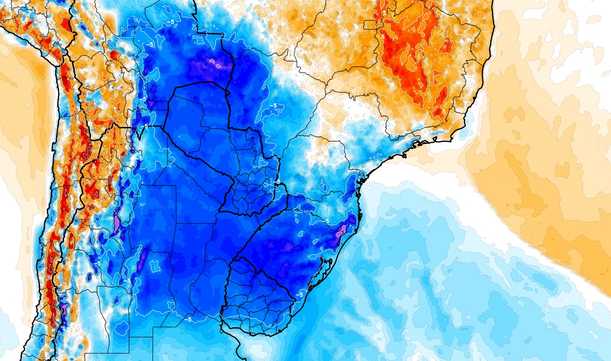
The numerical models emphasize the indication of frost, which is relevant data when we arrive in October due to the end of the winter harvest and the start of the summer harvest. Every time a cold air mass of greater intensity enters at this time of year, rural dwellers become very concerned about the risk of late frosts.
Fortunately, frost is not expected to affect the main grain-producing regions of southern Brazil, according to MetSul projections based on the latest model results. The maps below show the Canadian model’s frost projections for tomorrow and Saturday.
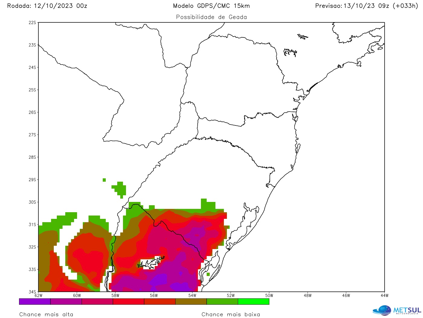

As we can see, the greatest tendency is for frost in Campanha, in the Serra do Sudeste and on the border with Uruguay, especially in the early hours of Friday. On Saturday, the risk of snowfall increases in the São José dos Ausentes region and on the southern plateau of Santa Catarina. In the cereal-growing areas of the Middle Plateau, frosts could be weak and isolated in the lowlands.
How to view maps
All model cards in this newsletter can be viewed by our subscriber (subscribe here) in our maps section. The platform also offers maps of rain, frost, temperature, hail risk, wind, humidity, atmospheric pressure, snow, soil moisture and fire and lightning risk, among other variables, with updates two to four times per day, depending on each simulation. In the maps section you can also view our very high resolution WRF model from MetSul.

“Prone to fits of apathy. Beer evangelist. Incurable coffeeaholic. Internet expert.”