
Excessive and extreme rain volumes should be expected in the second half of this week in part of southern Brazil, MetSul Meteorologia warns. Very heavy precipitation accumulations are expected to cause flooding, river flooding and flash flooding. The situation can be considered extremely risky and dangerous, given the extreme volumes and where they are expected to occur, on some of the major watersheds.
An exceptionally warm air mass continues to act as a heat bubble over Central-West and Southeast Brazil with historic and unprecedented temperatures in some cities. This bubble of superheated air is directly linked to the anticipated extreme rain event.
In fact, the bubble blocks the instability and it rains a lot on the periphery of the superheated air mass, that is to say in the southern states of Brazil. This situation results in the recording of several consecutive days of precipitation, which ultimately results in excessively high precipitation totals.
This was not enough and, even more worrying, the excessive rain expected for this second part of the week adds to the already very high volumes occurring in recent days. In the last five days, for example, it has rained more than 100 mm in several towns in the northern half of Rio Grande do Sul, with records of, for example, 127 mm in Serafina Corrêa and 117 mm in Caxias do Sul .
Conditions present a high risk of heavy to intense rain between the northern half of Rio Grande do Sul and Santa Catarina today, tomorrow, Friday and Saturday. Over the weekend, especially Sunday, the instability tends to migrate north and the weather improves in the states of Rio Grande do Sul and Santa Catarina.
An area of deep depression followed by a cold front will significantly intensify instability in southern Brazil between Friday and Saturday, increasing the risk of locally heavy to torrential rain with the possibility of very high precipitation volumes over a short period.
MetSul Meteorologia also warns that the same strong to intense instability that will bring lots of rain between the northern half of Rio Grande do Sul and Paraná during this second half of the week could also cause isolated wind and hail storms, some potentially strong to significant damage, but always localized.
What models project in the rain
The numerical models are unanimous in indicating too high volumes of rain for this second part of the week in southern Brazil. It is of great concern that it is indicated for the northern half of Rio Grande do Sul, where accumulations are expected to be extreme in some points with marks of 200 mm to 300 mm in some towns only between today and Friday evening.
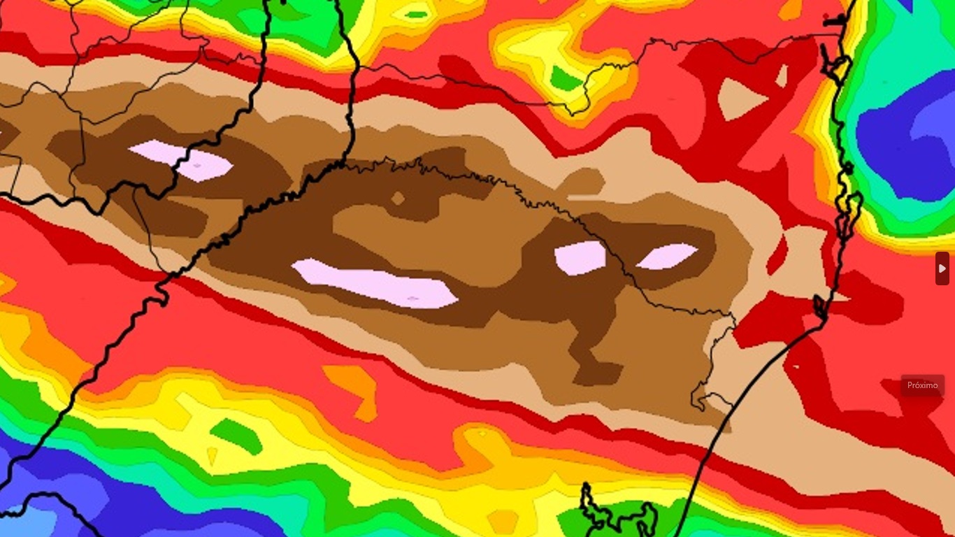
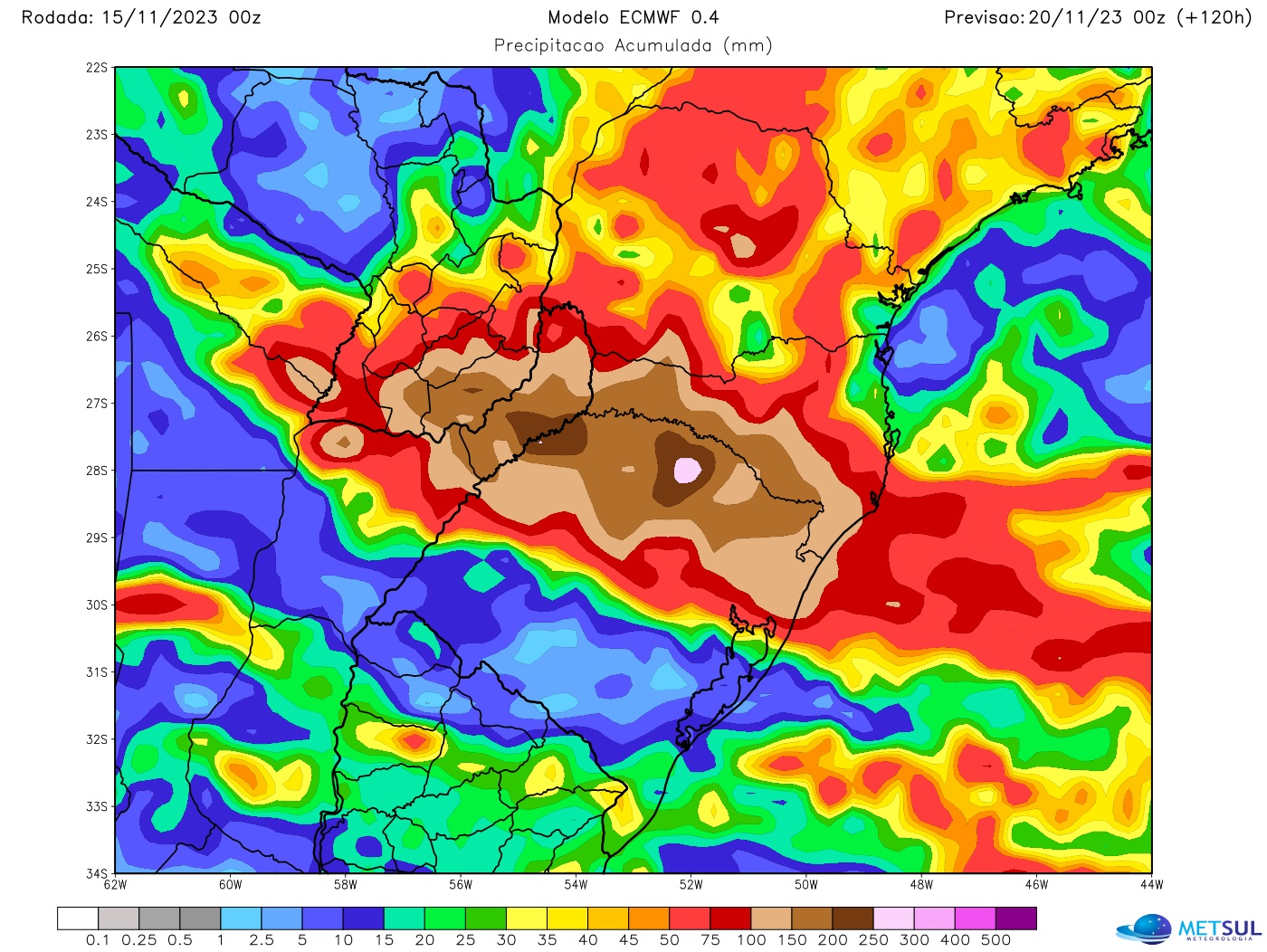
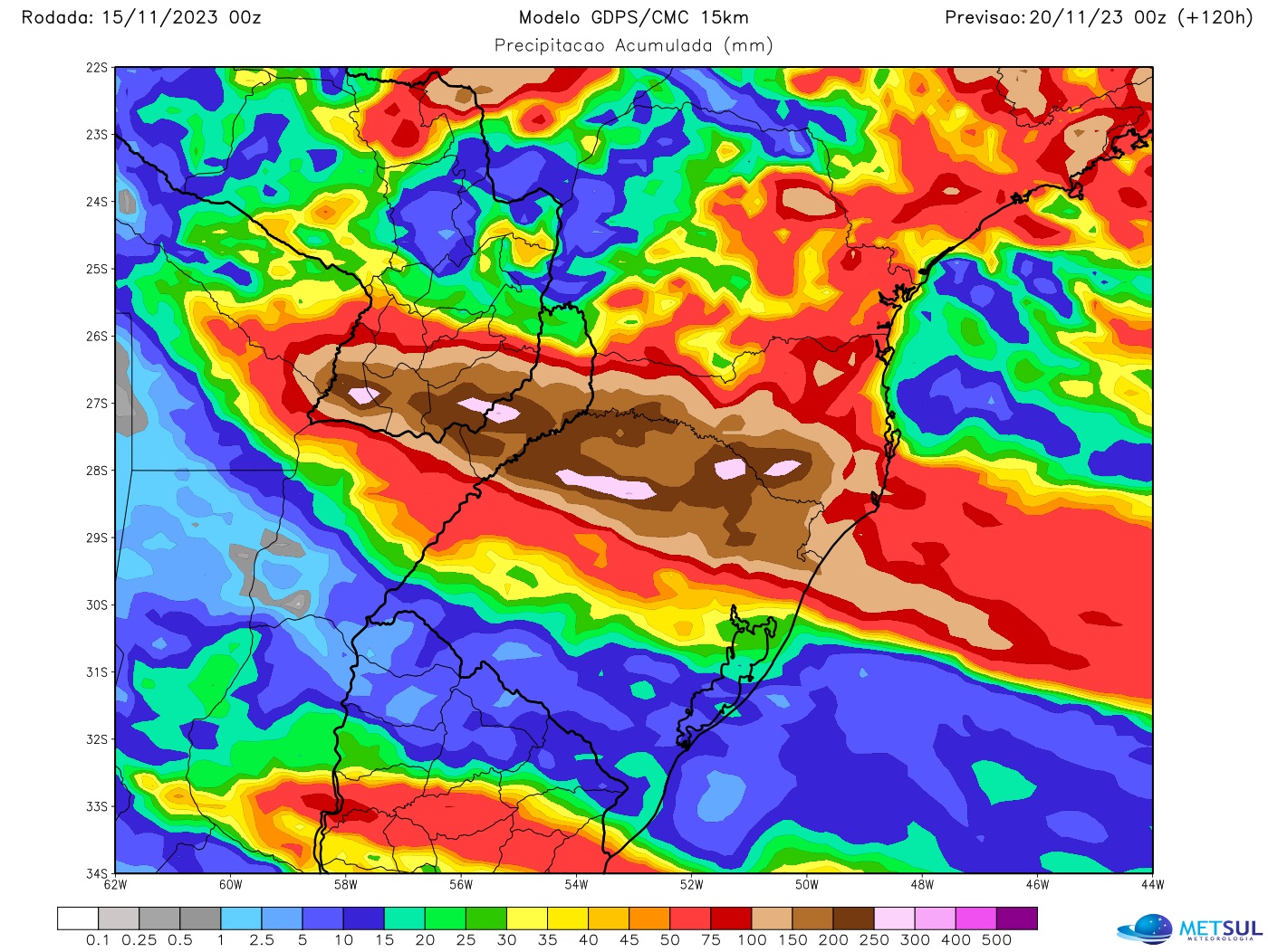
The model projections are very similar in the particular distribution of rainfall, with the highest precipitation accumulated through the weekend concentrated in the northern half of Rio Grande do Sul, Santa Catarina and Paraná. The variations only concern the volumes from one place to another, but always very high. The maps below show five-day precipitation projections from the German Icon, Canadian CMC and European Meteorological Center models.
METSUL WEATHER
METSUL WEATHER
METSUL WEATHER
The indication of the models, as can be seen, is volumes of 100 mm to 200 mm in almost the entire northern half of Rio Grande do Sul and part of Santa Catarina, but with points where precipitation accumulations can reach levels as high as 200mm to 300mm, almost two months of rain in just five days.
The southern half of Rio Grande do Sul would escape this excessive rain episode with much lower rainfall totals, but it has already rained heavily with scores of 100 mm to 150 mm in southern Rio Grande do Sul between the end from last week. and the beginning of it.
Flood warning
With what has already rained and precipitation still expected for this week, MetSul warns of significant impacts for the population and, in some municipalities, serious. Cities will again experience floods and floods, repeating the scenes of recent weeks and months in southern Brazil.
Of great concern, particularly in Rio Grande do Sul, is that excessive and extreme rainfall volumes are expected to occur on the headwaters of major rivers in the northern half of Rio Grande do Sul. This leads us to warn of a high risk of flooding of the rivers that cross valleys such as the Taquari-Antas and the Caí. Sinos can also be full. Gravataí presents a lower risk. It should still rain a lot in the Jacuí springs and especially in the beginning of the Uruguay River basin.
Rainfall with accumulations as extreme as expected also carries geological risks. The risk of landslides on the hillside will be very high. There must also be barriers that could result in partial or total blockages of state and federal highways.
Some roads, particularly municipal and rural, are expected to become impassable, with sections and ridges likely covered in water. Due to the prospect of strong currents, flooded sections should be strictly avoided by drivers at risk of fatal accidents.
How to view maps
All rain maps in this newsletter can be viewed by our subscribers (subscribe here) in our maps section. The platform also offers maps of rain, frost, temperature, hail risk, wind, humidity, atmospheric pressure, snow, soil moisture and fire and lightning risk, among other variables, with updates two to four times per day, depending on each simulation. In the maps section you can also view our very high resolution WRF model from MetSul.
MetSul Meteorologia is on WhatsApp channels. register here to access the channel in the messaging application and receive forecasts, alerts and information on the most important weather and climate events in Brazil and around the world, with exclusive data and information from our team of meteorologists.

“Prone to fits of apathy. Beer evangelist. Incurable coffeeaholic. Internet expert.”